

Why is Chechnya asking for a way to Georgia?
"This road provides independent exits with neighboring countries - Georgia, Armenia, Azerbaijan, Turkey, Iran, which have developed transport communication by sea and rail. "Given the situation around our state, this issue is becoming even more important," – stated Muslim Khuchiev, the Chairman of the Government of the Chechen Republic in a meeting with Nikolai Patrushev Secretary of the Security Council of the Russian Federation, in Grozny, March 15, 2022.
The Russian Federation is almost completely isolated as a result of sanctions imposed on Ukraine over its invasion and hostilities.
"New challenges are emerging due to the rise of anti-Russian sanctions. "The current geopolitical situation shows the need for government agencies to work harder to find new opportunities to establish new contacts with neighboring countries in order to increase the flow of goods from their territories," Khuchiev says that the Chechen Republic has been actively working for several years to organize the border crossing on its territory in Georgia. "In 2019, Putin was addressed on this issue, to which Vladimir Vladimirovich noted:" This is a good idea, but we do not have a practical plan in the Ministry of Transport yet. There is no doubt about the practicality of its implementation. "
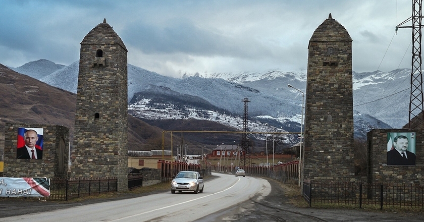
Itum-Kali Highway - Border Post "Arghun" - Georgian border, the length of which, according to Khuchiev, is 41.2 km, meets with 79 km long Grozny-Shatoi - Itum-Kali section of the federal highway:
"This road passes on the border with Georgia in the direction of the village Shatili. Construction of the road began in the 90s, but was halted due to the start of hostilities. Today, a 41.2 km long section is located in the border zone of the Russian Federal Security Service in the Chechen Republic. This road is of great strategic importance for the Russian Federation. I would like to ask you to discuss this issue, to be interested, to invest in this project. Maybe this road is not only free but also done for a fee as an alternative to Upper Lars. "I would like to ask you to consider this as a priority issue of national security at the next meeting of the Security Council and instruct the Russian Ministries of Transport, Foreign Affairs, and Economy, the Federal Security Service to consider this initiative."
Patrushev promised to submit the draft to the Security Council for consideration.
The leaders of the Chechen Republic have repeatedly stated the need to open the road to Georgia.
There is also a technical-economic substantiation of the Grozny-Shatoi-Itum-Kali-border post "Arghun" - Georgian border road.
According to the document, which is dated 2021 and prepared in Russia, the construction of the Grozny-Shatili road may be completed by the end of 2024 and the border checkpoint will be built on the same date.
Including the construction of bridges over the Arghun River, the cost of road reconstruction works is 10 billion rubles ($ 104 million). The document states that the project is impossible to implement without funding from the federal budget. Arguments for road construction include:
- Improving the economic situation in the mountainous regions of the Chechen Republic.
- Increasing the quality of life of the population.
- Strengthening international relations.
- Strengthening contacts with the diaspora.
- Other changes.
In a live broadcast on Instagram in June 2021, the leader of the Chechen government, Ramzan Kadyrov, said that the construction of a road from Chechnya to Georgia was under discussion: "It's 40-50 minutes from Itum-Kali to Georgia. There used to be a road between us. If we open this road, we will get to Turkey through Georgia, and then to Europe. This is an important road for the North Caucasus, as well as a railway. I think we should open this road in the near future."
The issue of construction of the Grozny-Shatili road, three years ago, once again became topical when the construction of a ski resort in the Chechen village of Veduch began. The village of Veduchi is close to the Georgian border - a 1-hour drive from Shatili. In addition to Veduchi, this area is home to one of the most significant archeological sites in the North Caucasus - Tsoi-Pede, known as the "Dead City" (due to its many terrestrial tombs), from the XV-XVIII centuries. Jarego and other villages are in Itum-Kali district. Here is the highest point of Tuloi-Lami mountain (Georgian - Tebulo mountain) - 4493 meters high, which attracts climbers.
The video of the Chechen vlogger, Magomed Mamushev, in which he introduces us to the "dead city", clearly shows the road from Chechnya to the Georgian border - Shatili.
Kadyrov made one of the first statements about the construction of the Chechen-Georgian road in 2014: "We plan to build both a road and a railway in Georgia. The government is working on it now. "According to him, until now, the implementation of this project was hindered by the former President of Georgia Mikheil Saakashvili.
History of the Chechen-Georgian road
The construction of a road from Itum-Kali to Shatili was started by the Chechen government in 1997. By that time, the first Russo-Chechen war (1994-96) had already ended, with 100,000 civilians killed, twice as many wounded, and half a million displaced. Russian special services have killed the first president of Chechnya, Jokhar Dudayev. In early 1997, Ichkeria's majority elected Aslan Maskhadov president. In the summer of the same year, a Chechen delegation led by Maskhadov arrived in Georgia, hosted by President Eduard Shevardnadze. Maskhadov and Shevardnadze also arrived in the Pankisi Gorge, where ethnic Kists live.
Chechnya is bordered by the Russian Federation on all three sides - the Stavropol Territory to the north, Dagestan to the east, North Ossetia and Ingushetia to the west. It has an independent state only in the south – Georgia. Shatili is the only border, which was not under Russian jurisdiction.
The government of Ichkeria built the road from Itum-Kali to Shatili in two years and reached Anatori (village near Shatili - at the confluence of the Arghun valley and Andakistskali). At that time, the actual border between Georgia and Chechnya was at the Alako gorge, the Chechens also had a small post there. From Anatori to Alako gorge, about 1000 hectares, including Pitchvni population, were controlled by Georgia.
Even before the start of the second Chechen war, Tbilisi demanded the cessation of road construction in Grozny. By that time, the criminal situation in Chechnya had already deteriorated sharply. At the same time, Russia demanded from Georgia to establish a joint commandant's office in Khevsureti. Russia explained this request by the fact that terrorism suspects did not cross from Chechnya to Georgia. During the same period, the Russian authorities sent three letters to the Georgian government requesting consent to the construction of the Dagestan-Georgia (Beshta-Akhalsopeli-Kvareli) road. Russia has rejected all demands from the Georgian side.
In September 1999, the Second Russia-Chechnya War broke out. About 8,000 refugees entered Georgia from Chechnya, almost half of them in the Arghun gorge by freshly cut machinery.
"A lot of people came in, mostly civilians, who came to Shatili in their cars or on foot. In Khevsureti they met other transport and from there, they moved to Tbilisi and Pankisi. I remember it was the late fall-winter period. There was little water in the river. In Arghun, cars were able to get out of the water directly without a bridge," said Shota Arabuli, a resident of Khevsureti.
Soon the Russian military moved the actual border from the Alako gorge and stood a few hundred meters from the Anatori.
How Pitchvni came under Russian control
Karua Zviadauri, 87, is one of the last inhabitants of Pitchvni. When refugees from Chechnya began to enter Shatili, she was still in Pitchvni with her husband. The border guards from the Shatili sector of the Georgian Border Guard Service warned the couple to leave the village and return to Shatili:
"Rooms, bed, flour, hay supplied for winter. There were Russians, bombing the Kists. So poor Kists, used to sleep in cattle-shed.
The Pitchvni was a good place, the boundary between us and the Kists. We used to go in the fall and come in the spring, May three, four, so on. We had a pasture, man, it was a pasture and we were making hay there. Nor did we fight the Kists until it came to the Russians. Then they got angry and so did we.
The place was called Alako. It was owned by Kists. Pitchvni , meadow, pasture, and ravine were ours.
Jarego is the first village beyond Alako, no one has lived there for a long time", - after February 2000, the Shatilions did not set foot in Pitchvni. Cattle-sheds and small houses built for housing have collapsed. They can hardly be seen even on maps.
Just below the Pitchvni is now the border post "Arghun", which is under the control of the Russian Federal Security Service. On the map, the Georgian-Russian border runs through Pitchvni here, near the upper Anatori (Mutso turn). The ancient shrine of Khevsureti - the icon of Anatori - remained on the Russian side.
"Mtis Ambebi" requested information from the Border Police of the Ministry of Internal Affairs of Georgia, from which year Pitchvni came under Russian control; Where the Georgian Border Police checkpoint / sector was located; Under what conditions did the Russian military occupy this part of Khevsureti and where Russia now has a border post built, is it Georgian territory or not.
The Border Police provided us with public information in violation of the law, only after we had lodged an administrative complaint.
Giorgi Malania, Deputy Chief of the Border Police, answers that the village of Pitchvni (or Pitchvebi) cannot be located in the cartographic materials of the Georgian Border Police.
"As for the historical context of the issue, it goes beyond the competence of the border police. "The Shatili checkpoint / sector was located near the village of Shatili, the location has not changed and it is still functioning," the letter reads.
What really happened: On May 19, 1999, experts from the State Border Delimitation and Demarcation Commission of the Russian Federation arrived in Tbilisi. The working meeting was held at the Ministry of Foreign Affairs of Georgia and lasted for 2 days. On May 21, experts from both sides signed a protocol, according to which Pitchvni belonged to Russia.
Gela Khutsishvili worked as the Deputy Chairman of the State Department of Border Protection of Georgia in 1997-2002. "Jansug Kekelia, a well-known cartographer and member of the commission, was not present at this meeting of experts. They did not go to the field, so they made a decision that is not final, but then, when the Russians crossed the border, they were guided by this protocol. In fact, the border was set beyond Pitchvni, 1.5 km from the confluence of the Arghun and Andak rivers. Such irresponsible and careless actions of the experts created the situation that we lost up to 1000 hectares of territory. This document was drawn up in the form of a protocol and sent to the Border Department, the Ministry of Foreign Affairs, and the Parliamentary Committee on Defense and Security. On December 28, 1999, when I arrived in Shatili on a business trip, I was guided by an old document that demarcated the border to 1.5 miles. I also set up a guard group near the Pitchvni tree, near Koba Chincharauli's house, consisting of 7 guards. The Russians were standing there, here we are. The situation was similar near the ridge of the village Mutso, there is a small section.
Unfortunately, time passed and it turned out that this document was a guide for Russia. They demanded the restoration of the status quo in accordance with this protocol, which was also signed by our experts. Later, they occupied this height because of the passage from here to the valley of Asa, to Arkhot. We retreated and stood at the confluence of the Andak and Arghun rivers, losing control as well.
The Georgian side accused me that if I had not set up a checkpoint, the Russians would not have come to Maketi. We removed this checkpoint in a month. Our border guards could be endangered by the Russians there because we were standing there illegally and the basis for this protocol was. After the withdrawal of our guards, in March 2000, the territory was occupied by the Russians.
Before the guards were taken out, Koba Chincharauli, who lived there, was seriously ill. He could not be transported. I took the helicopter, which was supposed to take me from Khevsureti to Tbilisi, near Koba's apartment and we took Him.I warned Russian that we were in the air, lest something misunderstood happen. A criminal case has been launched on this, alleging that Gela Khutsishvili exceeded his rights and duties and invaded Russian territory. "Then the case was stopped, but first I was transferred to the staff and then I was released."
There are several arguments why the Georgian side experts should not have signed the protocol by which we attributed Pitchvni to the Russian Federation:
- Joint land use in Khevsureti. They have a continuous, centuries-old tradition of nomadism. Due to the small size of the land, the residents of Shatili, who owned cattle, moved to Atsekhi, Pitchvni, and Mutsoschala for winter living, where they had cattle-sheds, and from the surrounding pastures, they stocked hay for the winter. The people of Ardoti still live like this, they are in Ardoti in summer, in late autumn they move three kilometers beyond Bakho to the right side of Andakistskali and take the goods there. Khevsureti people have chosen such places for wintering, even in winter, when the day is short, the sun is shining and the snow melts soon. Such places are more convenient for agricultural activities.
- The 1929 Resolution of the Central Executive Committee (CEC) of the Soviet Union, which established several sections of the Russian-Georgian border, including Pitchvni and its environs. According to the coordinates given in the resolution, this territory belongs to Georgia.
The document could not be located in the archives of Georgia. It became available to the Georgian side in 1998 when the Georgian-Russian sides were discussing the issue of the village of Aibga in Abkhazia. Aibga is a village in the Gagra municipality of the Autonomous Republic of Abkhazia and the Sochi region of the Krasnodar Krai of the Russian Federation. The village is located on both banks of the river Psou. The Russian side believed that the above-mentioned resolution of the CEC would resolve the dispute over the Aibga issue in favor of Russia.
Iveri Melashvili, former head of the Department of Neighborhood Delimitation, Demarcation and Border Relations of the Ministry of Foreign Affairs of Georgia, a former member of the Commission, and head of the group of experts, confirms that after receiving this resolution, the Georgian Foreign Ministry sent a note to the Russian Federation regarding Pitchvni.
"According to the maps published during the Soviet era, Pitchvni was on the side of the Russian Federation, however, according to the land use materials, including the land use map, it was in our use. After getting acquainted with the 1929 resolution of the CEC, which in its time could not be found, unfortunately, was not in our archives, Georgia appealed to the Russian Federation regarding the Pitchvni, that this issue is still under discussion. Until diplomatic relations with Russia were severed and delimitation commissions worked, this section was not agreed upon at that time, and it is still the case."
The total length of the land section of the state border of Georgia is 1839 kilometers. From here - 275 km with Turkey, 224 km with Armenia, 446 km with Azerbaijan and 894 km with the Russian Federation. Border delimitation Demarcation we have completed only with Turkey.
Shatili Road
Following the resumption of the Chechen-Georgian road, the Georgian Ministry of Regional Development and Infrastructure issued a statement: "Georgia has never considered, nor will it consider, the construction of any road connecting Chechnya. "The issue of road construction has never been on the agenda of the Georgian side and, therefore, any information about it is false."
Shota Utiashvili, an expert at the Georgian Foundation for Strategic and International Studies and former head of the Information-Analytical Department of the Ministry of Internal Affairs, also believes that Georgia does not need the Chechen-Georgian road and that it is not acceptable to the Russian government either:
"The more isolated Chechnya is, the better for Russia. Dagestanis and Chechens with whom I have had contact in recent years think the same. They say that the road to Georgia will be good, but the Russian government will not build this road for us.
I do not think that the Georgian government, even this government, needs this way of doing things. Especially against the background that we are spending hundreds of millions of dollars to improve Lars Road. We are building Kvesheti-Kobi tunnel and it is one of the most expensive projects that has been implemented. Consequently, if we spend so much money here, both the Dagestan project and the Chechen project, to put the political part aside, it would be costly and technically difficult. I do not think anyone has the money or the political will to do this.
Now, in this situation, when Russia is under sanctions and it seems that as long as Putin is there, the sanctions will not be lifted. Neither the World Bank nor any donor will fund this path. The Georgian government will not be able to finance this road, even if it wants to, we do not have enough money. All our road construction is funded by international donors, some with grants and mostly loans. Nobody will finance it, and also it would be madness to invest extra money in developing economic relations with Russia."
Zhinvali, from where the Shatili road starts, is 54 kilometers from Tbilisi. It is 100 kilometers from Zhinvali to Shatili. For years the road was very damaged, narrow, and dirt. In some sections, the two cars could not even pass each other. The journey from Tbilisi to Shatili took 5-6 hours, now it is possible to go in 3.5-4 hours.
The Government of Georgia started the rehabilitation of the Zhinvali-Barisakho-Shatili road with the funding of the state budget and the World Bank in 2018 and spent more than 59 million GEL. As part of the rehabilitation, the road was widened, asphalt and concrete pavement was laid for 60 kilometers, 17 new bridges were built and five were rehabilitated. Several bridges were damaged due to antiquity. However
The parameters of the newly built bridges (width, durability) made even the residents of Khevsureti doubt that the improvement of this road was not only for the safe transportation of them and the tourists.
Moreover, in some villages of Shatili, where people live permanently or for at least 7-8 months, they do not have a car road at all - they never had it in Khakhaboschala and Archilo, but in Andak and Khone the river took them years ago and the government did not take care of it. The Khevsureti, who are left stranded, carry the product on horseback and on their backs, through pedestrian bridges over the rivers, at any time that may collapse and be swept away by the water.
The highway connecting Shatili was built in the 1970s and runs through Datvisjvari Pass, at 2677 meters above sea level. The pass section starts from the village of Khakhmati and ends in Lebaiskari. Due to heavy snowfall and avalanche danger, the pass is closed at the end of November and will not be opened until mid-April, until May. Locked up to 5 months a year. In winter it is possible to go to Khevsureti by helicopter. A Border Police helicopter flies once every two weeks to change the guards. In bad weather, when it is cloudy, strong winds and visibility is difficult, there is no flight. In such a case, if a person becomes ill in Khevsureti and needs emergency medical care, they have the only doctor, Mikheil Chincharauli, without medical equipment.
In Pirikita Khevsureti, on the Shatili side, there are still several villages permanently living - up to 30 people in Shatili, 9 in Mutso, 2 in Ardot, 1 in Andak, 8 in Khone, 2 in Khakhabo. In winter, the fact that the rest of Georgia is separated for 5-6 months is one of the main reasons for the evacuation of Khevsureti.
To prevent the road to Shatili from being closed due to heavy snow and avalanche danger, the solution is to cut a 5-6 km tunnel from Khakhmati to Lebaiskara under Datvisjvari Pass. "Mtis Ambebi" requested information from the Roads Department of Georgia on whether there is a tunnel project under the Datvisjvari. We have not received a written answer yet, but we were told there was no tunnel project during the telephone conversation.
